It's Sunday evening. The forecast shows 5 inches of snow overnight. Your kids are already hoping. You're quietly hoping too — or at least hoping you can plan around whatever happens. The question echoing in every household: will there be a snow day tomorrow?
The answer isn't random. School districts follow real decision frameworks built around weather data, road conditions, and historical precedent. Once you understand that framework — and use the right tools — you can predict a snow day with surprising accuracy the night before. Here's everything you need to know.
How Snow Days Are Actually Decided
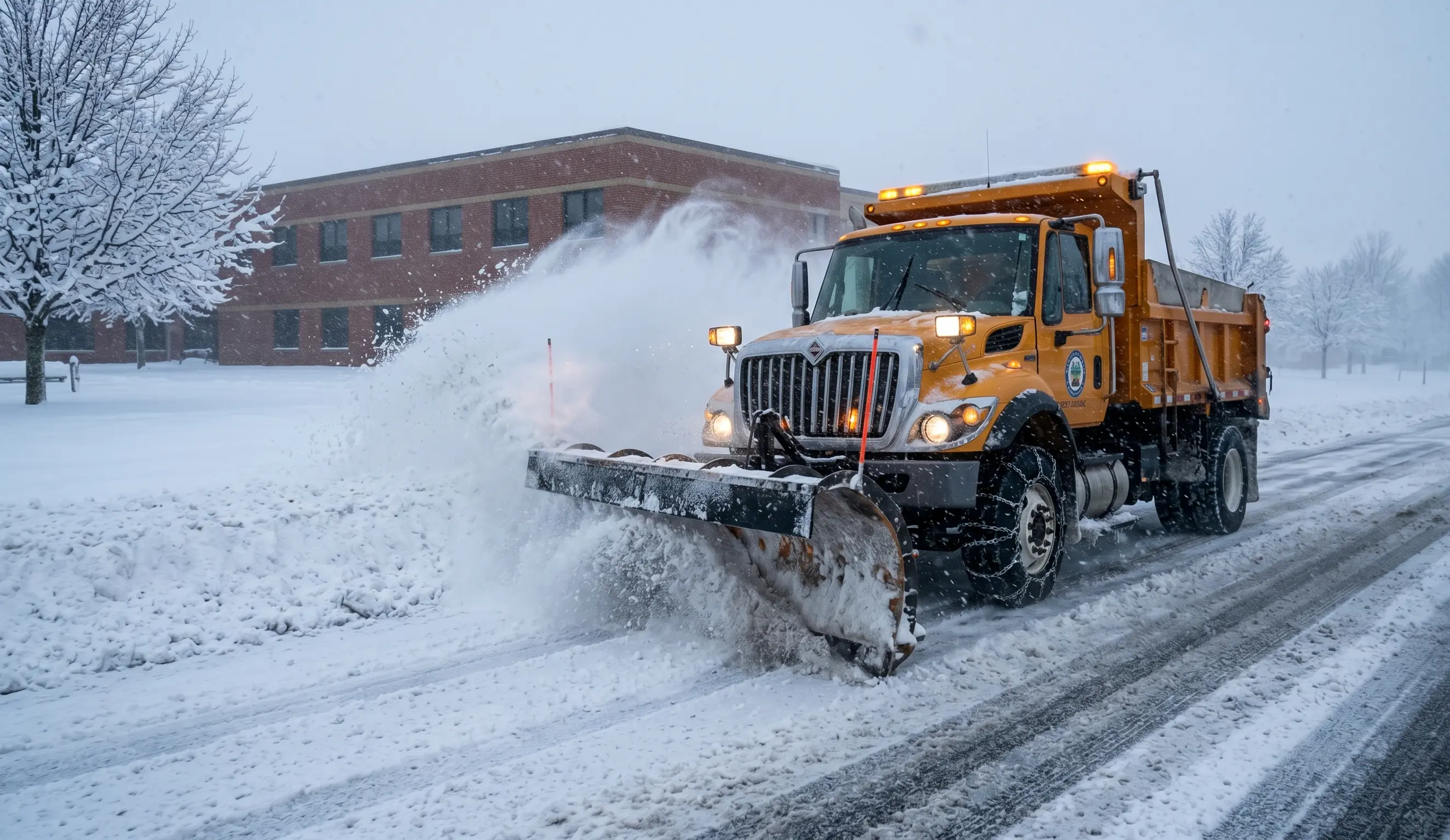
Contrary to what many parents believe, school superintendents don't wake up at 4 AM and look out the window. The process starts much earlier and involves multiple data inputs — most of which you can access yourself.
The core decision chain looks like this:
- The district receives overnight National Weather Service (NWS) forecasts for their specific county zone.
- The transportation director checks road condition reports from the state DOT, updated as early as 3 AM.
- Bus drivers report in on whether vehicles start and whether visibility is safe.
- The superintendent weighs all inputs against the district's written closure policy (yes, most have one).
- The decision is communicated — typically between 5:00 and 6:30 AM — via automated calls, email, apps, and local TV.
The key insight: every piece of data in that chain is publicly available. That's exactly why AI-powered tools like the Snow Day Calculator can process it automatically and give you a probability score the night before.
Snow Thresholds by Region: The Numbers That Matter
The single biggest variable in any snow day prediction is geography. A 3-inch forecast means completely different things in Atlanta versus Buffalo. The table below reflects real-world cancellation patterns documented across hundreds of school districts.
| Region / State | Typical Cancellation Threshold | Notes |
|---|---|---|
| Deep South (GA, AL, MS, SC) | 1–2 inches forecast | Any icing or freezing rain triggers closure |
| Mid-Atlantic (VA, NC, TN) | 2–4 inches | Ice more decisive than snow totals |
| Northeast (NY, NJ, PA, MA) | 4–8 inches | Urban districts more tolerant; rural close sooner |
| Midwest (OH, IN, IL, MI) | 5–8 inches | Wind chill below -20°F triggers closure alone |
| Upper Midwest (MN, WI, ND, SD) | 8–12+ inches | Cold days (-30°F wind chill) close school; snow alone rarely does |
| Mountain West (CO, UT, ID) | 6–10 inches | Blowing/drifting snow and road grades factor heavily |
| Pacific Northwest (WA, OR) | 2–4 inches | Hilly terrain and ice make low totals dangerous |
| Texas / Oklahoma | 1–3 inches (or ice) | Any forecast of freezing precip triggers proactive closure |
These thresholds are starting points, not guarantees. A 6-inch snowfall in suburban Cleveland might not close school, but the same storm hitting on a Monday after a weekend of freezing temperatures and untreated side streets easily could.
Factors Beyond Snowfall: What Superintendents Really Look At
Snowfall accumulation is the headline number, but experienced superintendents weight several other variables just as heavily — sometimes more so.
Wind Chill and Extreme Cold
In the Midwest and Great Plains, wind chill is often the deciding factor. Students waiting at bus stops face genuine frostbite risk when wind chills fall below -20°F. Many districts have written policies requiring closure when the NWS issues a wind chill warning, regardless of precipitation.
Minnesota, Wisconsin, North Dakota, and South Dakota see multiple cold-day closures per season where the sky is perfectly clear but it's simply too dangerous to have children outside for any extended period. These are sometimes called cold days rather than snow days, but the outcome is identical: no school tomorrow.
Timing of the Storm
A storm's timing relative to the school day matters enormously:
- Overnight storm (midnight–6 AM): Highest closure probability — roads untreated, accumulation complete by bus time.
- Morning storm (6–9 AM): High probability — decision made before roads are plowed.
- Midday storm (10 AM–1 PM): More likely to trigger a 2-hour delay or early dismissal than full closure.
- Afternoon storm (after 1 PM): Rarely causes closure; may cause early dismissal.
Ice vs. Snow
Ice is almost always more dangerous than snow, and districts know it. A quarter-inch of freezing rain on roads and sidewalks is far more disruptive than 4 inches of fresh powder. Districts in hilly terrain — Appalachia, the Ozarks, the Pacific Northwest foothills — respond to ice with the same urgency that flat-terrain Midwest districts apply only to heavy snowfall.
When Do Schools Announce Snow Days?
If you're setting your alarm to check, here's the realistic timeline for most U.S. districts:
- 10:00 PM – midnight: Superintendent monitors evening NWS forecasts; preliminary decision begins forming.
- 3:00 – 4:30 AM: Transportation director checks state DOT road conditions; bus garage reports on starting temperatures and lot conditions.
- 4:30 – 5:15 AM: Final decision made by superintendent.
- 5:15 – 6:00 AM: Notification system activated — automated calls, email, school app push notifications, local TV station crawl submission.
- 6:00 – 6:30 AM: Decision appears on local TV/radio; district website updated.
"By the time most parents wake up, the decision has been made for 90 minutes. The call that matters happens between 4:30 and 5:15 AM — everything after that is just communication." — Former public school superintendent, Northeast Ohio
This means the best time to check a snow day predictor for accuracy is actually the evening before, after the 11 PM NWS forecast update. At that point, the overnight model data is stable and you're looking at nearly the same numbers the superintendent will see at 3 AM.
How to Predict a Snow Day Tonight
You have three main approaches, ranging from manual to fully automated:
Option 1: Read the NWS Forecast Yourself
Go to weather.gov, enter your ZIP code, and look at the overnight forecast discussion. Focus on: total accumulation range, start/end time of precipitation, temperature at ground level, wind speed, and whether a winter weather advisory or warning is in effect for your county. Cross-reference that against your region's typical threshold from the table above.
This works but takes 10–15 minutes and requires knowing your district's specific tolerance. Most parents don't have that context.
Option 2: Check Local TV / Social Media
Local meteorologists often post school closure likelihood estimates on their social accounts by 9–10 PM the night before a significant storm. This is valuable local context — they know the terrain and the district patterns. The downside is it's qualitative ("looks likely") rather than quantitative.
Option 3: Use a Snow Day Probability Calculator
This is the fastest and most data-rich approach. The Snow Day Calculator pulls your NWS zone forecast automatically, scores it against district-specific historical closure patterns, applies regional weighting for temperature and ice risk, and returns a percentage probability. Enter your ZIP code, get a number.
For tonight's storm, that number is your best single answer to "will there be a snow day tomorrow?"
How Accurate Are Snow Day Predictors? Real Data
Accuracy depends heavily on lead time and storm confidence. Here's how AI-based snow day prediction performs across different scenarios:
| Prediction Timing | Storm Scenario | Typical Accuracy |
|---|---|---|
| Night before (10 PM) | High-confidence storm (≥4" forecast, winter warning issued) | 80–88% |
| Night before (10 PM) | Marginal storm (2–4", advisory only) | 60–72% |
| Night before (10 PM) | Cold/wind chill event, no snow | 75–82% |
| Morning of (5 AM) | Any scenario | 90–95% |
| 2 days before | Any scenario | 45–58% |
The takeaway: evening-before predictions are reliable when a storm is high-confidence (a winter storm warning is in effect and accumulation is above your region's typical threshold). For marginal storms — where the difference between 2 inches and 4 inches is the deciding factor — accuracy drops, because the weather models themselves are uncertain.
No calculator, AI or otherwise, will reach 100% accuracy — because the final call always belongs to a human superintendent weighing local conditions. But an 80%+ probability estimate the night before is meaningful enough to plan your morning around.
Common Snow Day Questions Answered
Does freezing rain count more than snow for school closures?
Yes, almost universally. Freezing rain creates ice on roads and sidewalks that is more dangerous than equivalent snow accumulation, particularly in hilly districts. Even a quarter-inch of ice accretion is enough to trigger closure in most regions.
Can a school delay instead of closing?
Yes — 2-hour delays are extremely common for marginal storms. They give road crews time to treat primary roads without losing the full school day. If your snow day probability is in the 40–65% range, a 2-hour delay is often the more likely outcome than a full closure.
My district just closed — will it be a snow day tomorrow too?
Not necessarily, but back-to-back closures do happen when a storm stretches across two days or roads remain impassable. Re-check your snow day probability for the second day using updated overnight forecast data.
What about virtual/remote learning — does it replace snow days?
Increasingly, yes. Many districts that adopted remote learning infrastructure during 2020–2022 now use it as an alternative to traditional snow days. Check your district's calendar and policy — some have a fixed number of snow days before switching to virtual; others go remote automatically for weather events.
How do I get notified the moment a snow day is announced?
Sign up for your district's automated notification system (usually found in the parent portal). Most districts now use apps like ParentSquare, Remind, or SchoolMessenger that push notifications before 6 AM. Local TV station apps also have school closure alert features.